Bed and Breakfast near Eryri (Snowdonia National Park)
The National Park
Eryri National Park, known internationally as Snowdonia until the National Park Authority formally adopted the Welsh name in November 2022, covers 823 square miles of north-west Wales, from the north coast down to the Dyfi Estuary near Machynlleth. It is the largest National Park in Wales, the third oldest in the UK (designated in 1951), and home to over 26,000 people for whom Welsh is overwhelmingly the first language. Around four million people visit each year.
The park contains all 15 of Wales’s peaks above 3,000 feet, clustered across three mountain ranges in the northern section: the Yr Wyddfa (Snowdon) massif, the Glyderau, and the Carneddau. Yr Wyddfa itself, at 1,085 metres (3,560 feet), is the highest point in Wales and England and draws around 600,000 summit attempts a year. But the park extends far beyond one mountain: it encompasses glacial lakes, ancient oakwood, some of the oldest geology in Britain, a UNESCO World Heritage Slate Landscape, a coastline, and a network of valleys, rivers, and forests that together make it one of the most varied landscapes in Europe.
The pronunciation: “Eryri” is roughly EH-ruh-ree. “Yr Wyddfa” is roughly Uhr-WITH-va. Visitors using the Welsh names will find it appreciated locally: Welsh is a living, working language here, not a heritage curiosity.
Where to Stay: Position Matters
Eryri is large, and where you base yourself determines what you can easily reach. The park has no single centre, but three areas account for the majority of visitor accommodation:
- Betws-y-Coed (eastern gateway): the best-connected village in the park, sitting at the junction of the A5 and A470, with its own railway station and direct Sherpa bus access to Yr Wyddfa. Central to the Glyderau, Carneddau, and the Yr Wyddfa massif. Strong for walking, mountain biking (Gwydir Forest), and as a day-trip base for both mountains and coast.
- Llanberis (western side): at the foot of Yr Wyddfa, home to the Snowdon Mountain Railway and the National Slate Museum. The closest base for the Llanberis Path (the most popular summit route). More limited for access to the eastern ranges and the coast.
- Beddgelert (south-western side): a smaller, quieter village in the Glaslyn valley, with access to the Watkin Path and Rhyd Ddu Path on Yr Wyddfa. Beautiful setting but more remote from the A55 corridor and north coast attractions.
Other bases (Capel Curig, Dolgellau, Porthmadog, Harlech) each have their merits depending on your priorities.
For visitors who want the widest practical access to the full range of what Eryri offers (mountains, forest, coast, heritage, and transport links), a base in or near Betws-y-Coed provides the strongest all-round position.
The Mountains: What You Can Reach
Yr Wyddfa (Snowdon)
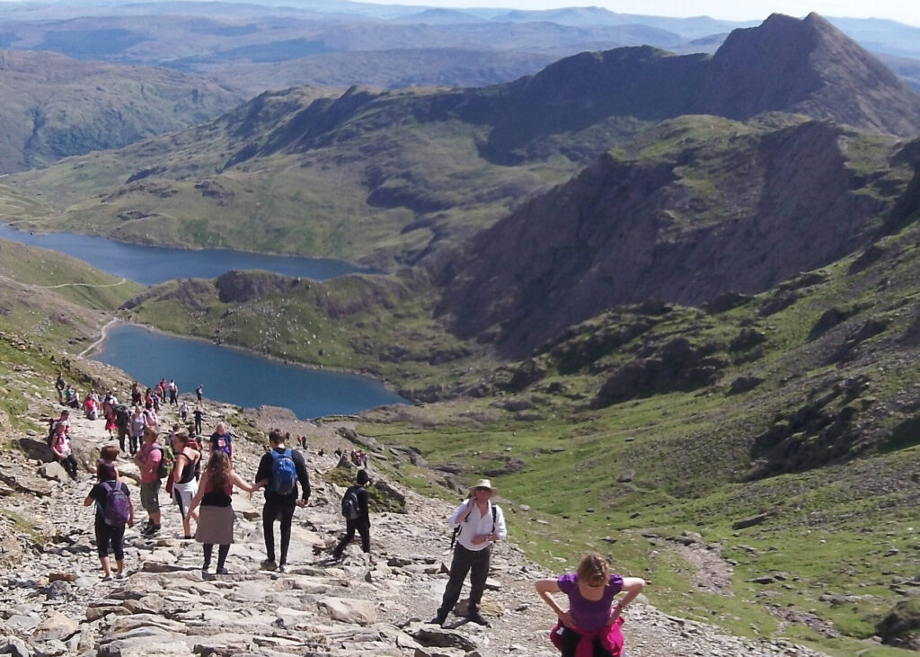
Six established paths lead to the summit, all classified as hard and strenuous by the National Park Authority. Even on the most gradual route (the Llanberis Path, 9 miles return), allow 6–8 hours for the round trip. The mountain demands proper footwear, waterproofs, navigation, food, and water regardless of the forecast: conditions change rapidly at altitude, and cloud can descend without warning.
The most popular routes from the eastern side are the Pyg Track and the Miners’ Track, both starting from Pen-y-Pass. The two paths run roughly parallel: the Miners’ Track starts lower, following the old copper mining route past Llyn Teyrn and Llyn Llydaw before steepening sharply; the Pyg Track takes a higher line with more immediate views. Most walkers ascend via the Pyg Track and descend on the Miners’ Track, creating a satisfying circular route. The paths merge near Llyn Glaslyn before the final climb to the summit ridge at Bwlch Glas, joining the Llanberis Path for the last stretch.
From Betws-y-Coed, Pen-y-Pass is about 25 minutes by car, or reachable by the Sherpa’r Wyddfa S1 bus which departs from the village and runs directly to Pen-y-Pass. Note that Pen-y-Pass car park requires pre-booking during the high season (April–October) and fills very early. The Sherpa bus avoids this problem entirely.
The other four routes approach from the western and southern sides and are accessible by other Sherpa routes: the Llanberis Path (longest but most gradual), the Watkin Path (shortest in distance but steepest, the toughest of the six), the Rhyd Ddu Path, and the Snowdon Ranger Path.
Crib Goch, the famous knife-edge arête connecting to the summit via the Snowdon Horseshoe, is a Grade 1 scramble and should only be attempted by experienced, competent mountain walkers in good conditions. It is not a path: it is an exposed rock ridge with serious consequences for a slip.
The Glyderau
The Glyderau range lies immediately north of the Yr Wyddfa massif, separated by the Llanberis Pass. It includes Glyder Fawr (1,001m), Glyder Fach (994m), and the iconic Tryfan (915m), the lowest of the Welsh 3,000-footers but arguably the most dramatic, with its twin summit stones (Adam and Eve) and a reputation as the finest small mountain in Wales. The traverse of Tryfan’s north ridge is a classic scramble; the descent via the south ridge or the Heather Terrace offers an easier return.
Between the two Glyders lies the Cantilever Stone on Glyder Fach’s summit plateau, a naturally balanced rock slab that has been a photography spot for over a century, and the jagged outcrop of Castell y Gwynt (Castle of the Winds), which was reclassified as a separate peak above 3,000 feet following a 2007 survey.
The main access point is the Ogwen Valley, reached from Betws-y-Coed via the A5 in about 20 minutes. Ogwen Cottage (Idwal Cottage) is the trailhead for Cwm Idwal, the Glyderau, and the southern approaches to the Carneddau. Car parking at Ogwen costs £8 per day (card only).
The Carneddau
The Carneddau are the most northerly 3,000-foot mountains in Wales, and the most undervisited of the three main ranges. This is a vast, open plateau covering roughly 10% of the entire National Park, with seven peaks above 3,000 feet including Carnedd Llewelyn (1,064m, the third highest in Eryri) and Carnedd Dafydd (1,044m). The terrain is different here: big, rounded ridges, fewer defined paths, more reliance on navigation. A herd of feral Welsh mountain ponies roams the high plateau year-round.
The Carneddau are accessible from Ogwen (south) or from the coast (north). They are quieter, wilder, and more committing than the Glyderau or Yr Wyddfa, and they reward walkers who value solitude over spectacle.
Moel Siabod
At 872m, Moel Siabod is below the 3,000-foot threshold but is one of the most satisfying single-peak walks in the park, a prominent pyramid visible from Betws-y-Coed with a well-defined ridge and superb summit views across the Yr Wyddfa massif, the Glyderau, and the Moelwynion. The standard route starts from Pont Cyfyng, about 10 minutes south of the village by car, and takes roughly 4–5 hours for the round trip. An excellent choice for a shorter mountain day or when the higher peaks are in cloud.
The Welsh 3000s
All 15 peaks over 3,000 feet in Wales lie within Eryri and are connected by a continuous walking route of approximately 26 miles (42km) with around 3,900m of total ascent. The Welsh 3000s Challenge, summiting all 15 in under 24 hours, is one of the iconic mountain challenges in the UK. The current record, set by fell runner Finlay Wild in 2019, stands at 4 hours 10 minutes. Most walkers spread it over two or three days. Betws-y-Coed, sitting centrally between the three ranges, is a natural overnight base for multi-day attempts.
Beyond the Peaks
Eryri is not only a mountain park. For days when the cloud is low, the wind is strong, or you want a change of pace:
- Gwydir Forest wraps around Betws-y-Coed and offers walking, mountain biking (the Gwydir Mawr/Marin Trail, Gwydir Bach, and Penmachno trails), and access to waterfalls including Swallow Falls and the Fairy Glen. No mountain gear required: forest paths are mostly well-surfaced.
- UNESCO World Heritage Castles: Conwy, Caernarfon, Harlech, and Beaumaris are all within a 40-minute drive, part of Edward I’s Iron Ring and collectively inscribed as a World Heritage Site.
- The Slate Landscape of North-West Wales: the newest UNESCO World Heritage inscription in the UK, centred on the quarrying landscapes of Llanberis, Bethesda, and Blaenau Ffestiniog. The National Slate Museum in Llanberis is free to enter.
- Bodnant Garden (National Trust): one of the finest gardens in the UK, 20 minutes north of Betws-y-Coed in the Conwy Valley.
- Zip World: multiple adventure sites across the park: the Fforest site near Betws-y-Coed, the Velocity zip line at Penrhyn Quarry (Bethesda), and underground activities at Llechwedd (Blaenau Ffestiniog).
- Heritage Railways: the Snowdon Mountain Railway, Ffestiniog Railway, Welsh Highland Railway, Conwy Valley Line, and Bala Lake Railway all operate within or adjacent to the park.
- The Coast: Conwy, Llandudno, and Anglesey are all under 30 minutes from Betws-y-Coed. The Menai Strait, the Great Orme, and the Llŷn Peninsula extend the range further.
Practical Considerations for Mountain Visitors
Weather
The weather in Eryri is Atlantic: maritime, changeable, and frequently wet. Summit temperatures can be 10–15°C lower than the valley. Rain, wind, and low cloud are possible in any month. Carry waterproofs, warm layers, and a hat even in July. Check the Mountain Weather Information Service (MWIS) forecast for Snowdonia before setting out: it is far more useful than standard weather apps, which report valley conditions and can give a dangerously misleading picture of what is happening above 600m.
Daylight
In midsummer, there is usable daylight from roughly 05:00 to 22:00. In midwinter, sunrise is after 08:00 and sunset before 16:00, a much tighter window for longer routes. Carry a head torch at any time of year.
Parking
Car parking at popular trailheads (Pen-y-Pass, Ogwen, Nant Peris) requires pre-booking during the high season and costs £5–£8 per day (card only). Car parks fill early, particularly on summer weekends. Staying in accommodation with its own parking and using the Sherpa bus to reach the mountains avoids this problem entirely.
The Sherpa’r Wyddfa Bus
The Sherpa network is the most practical public transport system for mountain access in the park. From Betws-y-Coed, the S1 service runs directly to Capel Curig, Pen-y-Pass, Llanberis, and Caernarfon. Other routes (S2, S3, S4) connect Bangor, Beddgelert, Porthmadog, and the western trailheads. During the high season (late March to early November), services run frequently. Welsh concessionary travel passes are accepted; English and Scottish passes are not valid for free travel on Sherpa services.
The Sherpa network is genuinely useful, not a token green transport gesture. It solves the parking problem, and using it from a Betws-y-Coed base means you can walk point-to-point routes (for example, ascending via the Pyg Track from Pen-y-Pass and descending the Snowdon Ranger Path to be collected at the other end).
EV Charging
Public EV charging infrastructure in Eryri remains limited, particularly away from the A55 corridor. If you are driving an electric vehicle, accommodation with a dedicated on-site charger is a significant practical advantage: it means you start each mountain day fully charged without needing to plan around public charge points.
Bryn Bella Guest House
Bryn Bella sits at the eastern edge of Eryri National Park, in the village of Betws-y-Coed, at the end of a long private driveway that climbs to an elevated position overlooking the Conwy Valley and the Gwydir Forest. The village centre, with its shops, cafes, station, and Sherpa bus stop, is a short walk downhill.
Why This Location Works for Mountain Visitors
Betws-y-Coed is roughly equidistant between the three main mountain ranges. Pen-y-Pass (Yr Wyddfa) is 25 minutes by car or a direct Sherpa bus ride. Ogwen (Glyderau/Carneddau) is 20 minutes on the A5. Moel Siabod is visible from the guest house. The Gwydir Forest trails start from the edge of the village. On a rest day, Conwy, Bodnant Garden, and Llandudno are all under 30 minutes north.
This is not a remote mountain hut: it is a comfortable guest house with a proper breakfast, drying facilities, and expert local knowledge, positioned to give you the widest practical access to the park.
Awards and Standards
AA 4-Star Gold rating and AA Breakfast Award. The Gold distinction recognises establishments that significantly exceed the standard requirements of the 4-Star rating. Joan and Mark Edwards have run Bryn Bella for over two decades.
The Rooms
Five ensuite guest rooms, double and king-size, with views over the Conwy Valley or the garden and Gwydir Forest. All rooms have Wi-Fi, TV, and hot beverage trays. Full details, photographs, pricing, and a virtual tour are on the accommodation page.
Prices from £85 per room per night (low season) to £110 per room per night (high season), including breakfast.
Breakfast
This matters if you are spending the day in the mountains. Breakfast at Bryn Bella is cooked to order from 08:00: eggs from the property’s own free-range hens, seasonal fruit and salad from the garden, and other ingredients sourced from within Conwy. A full Welsh cooked breakfast, lighter options, and dietary alternatives (vegetarian, vegan, allergen-specific) are all available. The kitchen operates a zero-waste policy and full allergen transparency.
A proper mountain breakfast, not a continental afterthought. Details on the breakfast page.
Built for Outdoor Visitors
- Parking: Free on-site, one allocated space per room. No need to compete for village car park spaces or pay £8/day at the public car parks.
- EV Charging: On-site Type 2 7kW charger and a 3-pin 3kW connector (ZeroNet network). Free for guests who book direct. Reserve the charger bay when you book.
- Drying Facilities: Assistance with drying wet gear and boots: essential after a day on the hill in typical Eryri weather.
- Local Knowledge: Joan and Mark are experienced outdoor enthusiasts. They know the mountain routes, the weather patterns, the conditions, and the alternatives for low-cloud days. This is the kind of advice that is hard to find on a booking platform and genuinely valuable on the ground, particularly for less experienced walkers or first-time visitors to Eryri.
- Guest Lounge: Stocked with walking guides, OS maps, and climbing reference books. Binoculars and a telescope are available for birdwatching from the garden, which supports nesting birds, hedgehogs, bats, and tawny owls.
- Cyclists and Mountain Bikers: Mark can advise on routes in the Gwydir Forest and beyond. The Gwydir Mawr (Marin Trail) and Gwydir Bach are accessible from the village, and bike hire is available locally from Beics Betws.
Getting Here Without a Car
- By Rail: Betws-y-Coed station is on the Conwy Valley Line from Llandudno Junction (connecting to mainline services from Chester, Crewe, and beyond). Journey time from the junction is about 30 minutes. Bryn Bella offers a complimentary collection from the station. Let us know your arrival time when you book.
- By Bus: The Sherpa’r Wyddfa S1 connects Betws-y-Coed directly to Pen-y-Pass and Llanberis. Exploring Eryri without a car from a Betws-y-Coed base is genuinely practical. There is also a Snowdonia Without a Car guide on the website.
Sustainability
Bryn Bella was the first guest house in Snowdonia to install EV charging (2012) and the first B&B in North Wales to receive a Green Tourism Gold award. Current accreditations include COPA Gold with Plastic Free Y Wyddfa and Silver SAS Plastic Free Champion. Solar-heated water, rainwater harvesting, on-site composting, native species planting, and paraben-free guest products are standard practice. Full details on the eco-friendly page.
Book Direct
Booking directly through our website or by phone (01690 710 627) gives you the best available rate, no booking fees, and the flexibility to arrange EV charger reservation, station collection, dietary requirements, or late check-in. Third-party platforms cannot offer these.
Check availability and book direct →
Have a question? See our frequently asked questions or get in touch.